My Visit from the FAA

On July 18th I experienced a partial loss of power in my Piper Comanche while approaching the St. Louis Down town Airport.   I requested an expedited landing into the airfield as I thought it best to get on the ground.

Video of approach and landing at KCPS


A note about the video.  About 1:10 you will see the engine stumble and notice that it seems to sound different and run differently.  After the landing you will see the fire truck parade.  It seems the approach folks got a little excited and declared an emergency for me.  I requested an expedited landing as the engine starting running rough and I lost the ability to generate some power.  I did not declare an emergency I only requested an expedited landing as I was unsure if I could do a go around if it was needed.  In the end, it was discovered that my right magneto had a broken rotor brush.  Seems it was still working sometimes and was throwing the engine timing off.  It all ended safely so no worries.

After landing and filling out paperwork with the fire department, we went on our merry way and I thought that was the end of it all.  No it was not.  A few days later I got a call from a very polite gentleman from the local FSDO.  He wanted to let me know that because of the incident, he was tasked with investigating the situation and wanted to meet with me.  I agreed to meet and then he asked me to bring my log books.  I explained that I was on vacation and did not have that information with me.   No worries he said you can send that along later.

Before I got the call from the FAA representative a few fellow pilots urged me to fill out a NASA report.  That is essentially a report where a pilot tattles on themselves for what we did wrong, which can help if any legal actions might be taken. I am glad I did so and believe it was a wise precaution.  It also helped me to organize my thoughts and present my finding when I met with the FAA representative.

So we met at the FBO and he asked to see the regular documents – my medical certificate and my pilot’s license.  I produced them and showed them to him.  Then he asked me what happened and I explained pretty much what I wrote just below the video above.  I asked him why all the fuss as I never declared an emergency and only asked to be expedited as a precaution.

This was news to him.  He was not aware of those circumstances.  He seemed to understand though and he wrapped up the questions by asking to see the plane. I took him out to the plane and showed him the standard documents. AROW – Air Worthiness Certificate, Registration, Operators Manual, Weight and Balance.

He looked at the engine, took a picture of the data plate and that was pretty much it.  He asked if I would start the plane, which I did and I flipped to the right magneto and it started popping and backfiring and generally running like crap.  This seemed to satisfy him that an actual problem existed in the plane.

He asked me about my plan to get it fixed.  I told him I was going to take it to the local shop on the field.  he asked me to send him a copy of the log entry once it was fixed, plus copies of the most recent annual inspection entry and the AD compliance report.  I explained that it would be a few weeks as we were on vacation.  He gave me his business card and that was it for that day.

When I returned home I had an email from the FAA Inspector reiterating the request for the documents.  I scanned them and emailed them off to him the next day.   So now we wait. I have emailed him back and asked that when the report is finalized that he email a copy to me.

Our Summer Trip 2015 – Part 1

Hello All
The summer trip has come to an end. We had a good time. It was much shorter than planned but we still did some fun stuff.   Our trip this year took us from Ocala to St. Louis then on to Oshkosh, Petit Jean State park, Memphis, Nashville, Crossville, and Spartanburg.

Link to the whole trip on Skyvector

The first leg of the trip took us from Ocala to West Georgia Regional Airport in Carrolton Georgia for a refuel stop.  Nice little airport.  We borrowed the courtesy car and went into town to grab a quick lunch.  The cheap and quick option was a Subway sandwich shop just a few miles down the road. We returned to the airport, lunch in hand and gabbed with some other pilots in the lounge for a bit while we ate and then climbed back in the plane and flew on to our next destination – St. Louis.

West Georgia Regional Airport KCTJ

West Georgia Regional Airport KCTJ

Video of the Landing in Carrollton

After lunch and a refuel we continued on to our first destination KCPS St. Louis Downtown, which is located in Illinois across the river from St. Louis proper.  I must admit it was very cool to look down the runway at the St. Louis Arch just across the river.  The flight was pretty easy we had good weather and a light tailwind so we picked up a few extra knots and cruised at about 135 kts at a70% power setting.

St. Louis Downtown Airport

Video of the landing at St. Louis Downtown 

A note about the video.  About 1:10 you will see the engine stumble and notice that it seems to sound different and run differently.  After the landing you will see the fire truck parade.  It seems the approach folks got a little excited.  I requested an expedited landing as the engine starting running rough and I lost the ability to generate some power.  I did not declare an emergency I only requested an expedited landing as I was unsure if I could do a go around if it was needed.  In the end, it was discovered that my right mag had a broken rotor brush.  Seems it was still working sometimes and was throwing the engine timing off.  It all ended safely so no worries.  The repair was simple and was completed by the shop on the field in a few hours.

We called ahead and the FBO, Ideal Aviation, arranged a rental car and a hotel for us at very good rates. For the next four days we stayed at a Drury inn and Suites to the east of the airport in O’Fallen Illinois, which was a bout a 20 minute drive from downtown.  I must say I am a big fan of that hotel chain.  In addition to a complimentary hot breakfast they also offered a complimentary simple dinner and free adult beverages every evening.    We would get up in the morning and have a lovely breakfast and then spend the day as tourists and return for a hot dinner and a cold beer.  From now on I will try to stay at this chain when I travel.

IMG_20150721_203027

I have to say that visiting the Arch was pretty cool.  It was a very easy drive from our hotel.  We drove across the Mississippi river and then right into downtown.  Finding parking was very efficient and inexpensive.  A short walk got us from our parking to the steps of the courthouse, where the above picture was taken.  Then a quick walk across the street and into the park under the arch allowed for a close up view of this magnificent structure.

Another interesting stop was the Cahokia mounds.  This is the remnant of a native american city that lasted some 300 years.  They build pyramids and had a whole city with walls and even their own version of Stonehenge – but with wooden poles.   Here is a link to the museum website: http://www.cahokiamounds.org/

So this was our first few days in St. Louis.  After this my wife went to her conference, and I continued on to Airventure at oshkosh.  Stay tuned for part two.

Tips for Cross Country Flying

I’ve made several long distance cross country trips in my private aircraft. I’d like to share some of the lessons I’ve learned.  This is by no means an exhaustive explanation of everything you need to know before taking a long trip.  Instead these are some key points I try to keep in mind while planning and flying over long distances in my own airplane.

The Entire Summer Trip Route

The Long Cross Country


Know Yourself

It is probably most important to understand your own experience and comfort level as a pilot. I remember my instructor talking about setting personal minimums.  I wrote my personal minimums on the inside cover of my log book and I still review them each time I write an entry.  Before tackling a long trip this would be a good item to review and keep in mind during the planning phase.  I know how much crosswind I can handle when landing my plane.  If the crosswind is too high I am going to rethink my choices.Windsock

One of the biggest killers of small aircraft pilots is a phenomenon called get-there-itis.  In get-there-itis, personal or external pressure clouds the vision and impairs judgment by causing a fixation on the original goal or destination combined with a total disregard for alternative course of action.  When you are getting ready to make a long trip check your own ideas about flying these long distances.  If you start using words such as “I have to be at this place by this time”, it might be a good time to take a step back and reevaluate your priorities for this trip.   Often pilots will develop get-there-itis and far exceed there own personal minimums by flying into conditions they would not normally attempt and find themselves in real trouble.

Know Your Aircraft

I most often fly a 1968 Cherokee 180 D.  After so many hours of flying I can tell when something is off just by the way the aircraft feels when I start it or when I am flying. I know pretty well how the plane is going to react to particular flight conditions.  Knowing these behaviors of the craft you are planning to fly is important.  I would not recommend taking a long trip in a plane I’ve never flown.  A better plan would be to get to know the plane on a few short trips and get comfortable with the particular quirks of that craft before ever attempting to make a long cross-country trip.

PA28 With 5 gallons of FuelFuel consumption is critical in a cross country flight and it is important to know how much fuel you can carry and how much your craft will burn in flight. I often plan to have more fuel than just the minimums at each landing site.  For example, my aircraft has a range of about 500 miles with day VFR reserves of 30 minutes.  Ever consider how little fuel 30 minutes represents?   In my plane that is about five gallons of fuel or two and half gallons in each tank.  The fuel gauges would barely be off the empty mark. I am not willing to take my plane down to that low of fuel.  A strong headwind can increase your fuel consumption considerably and leave your fuel tanks bone dry long before reaching your destination. For these reasons I always plan the legs of my flight to leave me with one hour of fuel upon reaching my destination.

Know Your Route

This may seem a bit fundamental but I try to have a really good idea of where I am going to fly. hudson-river 
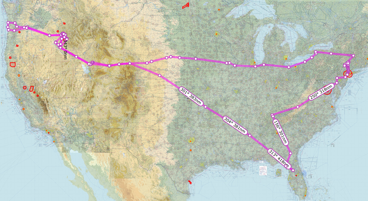
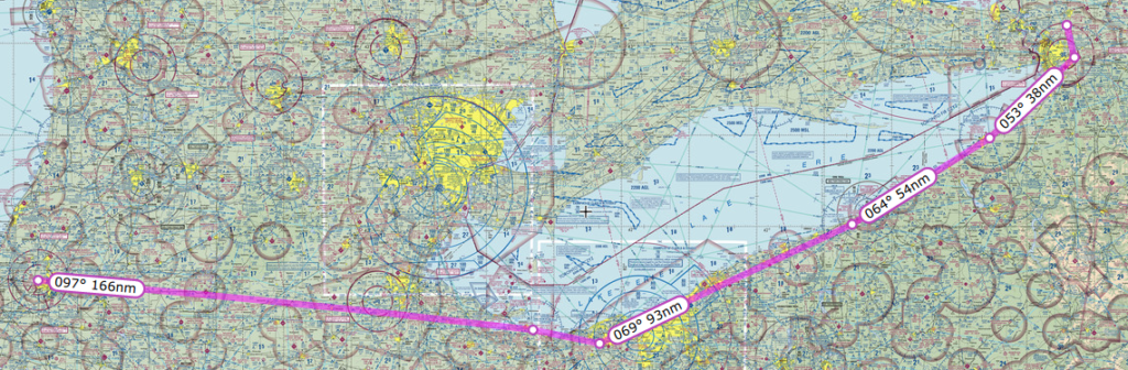
I take a good amount of time in planning my route, which involves activities such as studying the terrain along my chosen path and making note of any distinctive landmarks or features. I also review approach procedures for my landing sites, and mentally note any alternate or emergency landing sites.  I often go on YouTube and look for videos from other pilots that are flying routes and landing at the airports I might use.   You would be surprised at how much you can glean from watching a video of someone landing at an airport you might use along your route.

 Have a Backup Plan or Two or Three

When flying cross-country I try to keep in mind that the trip is not just about getting there, but also about the journey.  Although I plan on going to my primary landing site, I also plan a secondary and even a tertiary landing site.  This idea ties into knowing yourself.  If you keep an attitude of enjoying the journey and not being rigidly committed to a specific destination you can make better decisions about when to choose an alternate landing site.

Storms South of MiamiWeather conditions can change rapidly and no forecast is perfect.  If I see that the conditions ahead in the direction of my primary landing site are not looking safe, I might land sooner or turn on an angle away from my route and away from the weather.  When I plan backup sites I often pick one that is before my primary destination and then I also pick one on an angle to secondary.  For example if my destination for the day is 400 miles due west I pick an alternate that is 350 miles west and then another that is north or south.  This way I have alternates and ways to escape bad weather.

Know the Weather Patterns

When planning a long cross-country trip, I start obsessing about the weather probably two weeks before. Weather patterns are often cyclic and getting to know how the weather will behave during your time in the air is vital to a safe flight.   The official sources such as aviationweather.gov , DUATS and 1800wxbrief.com are essential sources.  I also like to use Weather Underground’s interactive maps and detailed forecasts to help get a better picture of the weather along my route.  I tend to stay away from the full-time newsy cable weather products as they tend to exaggerate and sensationalize the weather and in my humble opinion often give inflated and emotional forecasts.

So there you go some tips on planning and making a safe cross country flight.  I hope something I shared here helps you have an enjoyable and safe trip.

My Resume

Russell Wright

1842 SE 6th Ave, Ocala, FL 34471 ● 727.638.1559 ● russ.wright@gmail.com

Summary of Qualifications

A patient educator and mentor who understands the unique needs of adult learners, in on-line, classroom and blended environments.  Experienced, performance-oriented information technology professional with 15+ years of leadership experience in enterprise level systems analysis and software development.  A strong leader and team contributor who works well in cross-functional teams.  A confident worker who enjoys software development and learning new skills.  A problem solver with excellent communication skills both verbal and written.  A capable researcher familiar with quantitative, qualitative and design science research techniques.

Technical Expertise

Languages: Python, PHP, SQL, Dot Net, Visual Basic, VB Script, Javascript, CSS
Frameworks: .NET 4.0, CodeIgniter
Databases: MSSQL Server, MySQL, Postgres, Oracle
Software: R Commander, SPSS, SAS, Visual Studio, Eclipse, MonoDevelop, Gedit, Netbeans, Apache, IIS, MS Office, Open Office, Piwik Analytics, Google Analytics, AW Stats
Concepts: Systems Analysis, SDLC, Object Oriented Design (OOD), UML, Unit Testing, Statistical Analysis, Cyber Security
Platforms: Unix/Linux, Mac OS X, MS Windows


Education

Doctor of Philosophy in Information Technology

Capella University- Minneapolis, MN

Dissertation focus: The application of persistence theory to the graduate admissions process.


Master of Science in Information Technology

Capella University – Minneapolis, MN

Concentration:  Application Development


Bachelor of Arts in English

Massachusetts College of Liberal Arts – North Adams, MA

Concentration:  Writing and American Literature


Teaching Experience

Schiller International University, Largo, FL 2015-present

Adjunct Professor, MIS program

Conduct hybrid classes for the Masters in Information Systems program for topics such as Management of Information Systems, Database Design, Project Management and Data Communications and Networks.

Accomplishments

  • Currently leading a cohort of 25 foreign students though the MIS track courses.
  • Reworked and streamlined the course content in Blackboard for the MIS track.


College of Central Florida, Ocala, FL 2013 – 2021

Associate Professor, BAS Program

Responsible for the overall function of the BAS program.  Teach on-line, on-campus and hybrid courses in MIS specialization.

Accomplishments:

  • Created course content for several Information Systems courses including Cyber Security Fundamentals, Advanced Programming Concepts with Python, Database Management Systems with SQL, Web Programming with PHP and Advanced Systems Analysis.
  • Wrote 2 textbooks – Dynamic Web Page Design with PHP, Database Systems SQL.
  • Working with faculty and staff increased the rigor of the courses and established clearer guidelines for course content.
  • Assisted with the promotion of the program which increased enrollment by 40%.


Strayer University, Tampa, FL 2012 – Present

Adjunct Faculty, Tampa East Campus

Conduct on-campus classes in the Computer Information Systems program for topics such as network essentials, interface design, project management and web development.


Accomplishments:

  • In collaboration with the campus dean reintroduced CIS classes to the campus. Successfully recruited and retained students to complete the CIS classes at that campus.


St. Petersburg College, St Petersburg, FL 2010 – Present

Adjunct Faculty, College of Computer & Information Technology

Conduct quality on-line classes in Information Technology topics such as network essentials, introduction to programming and system analysis and design for an average of 25 students per class.  Provide support to students on writing skills and technical issues.


Accomplishments:

  • Introduced new on-line classroom communication techniques, which improved student participation in on-line discussions and perception of connection to the campus.


Capella University, Minneapolis, MN 2010 – 2011

Teaching Assistant, School of Business and Technology

In conjunction with course instructor, develop course materials and assess student mastery of academic skills and competencies as determined by course outcomes.  Facilitate on-line discussions among students to assist in their understanding of course materials.  Assist students with locating resources through the website and on-line library.


Accomplishments:

  • Significantly improved the retention of at-risk students an average of 30%.
  • Introduced new information presentation techniques, with videos and presentations, which improved the learner’s perception of connection to the classroom.


Professional Experience

Stetson College of Law, Gulfport, FL 2009 – 2012

Senior Developer

Provide research and guidance to management on all aspects of web technology solutions.  Acted as a liaison between the IT and Communications groups.  Responsible for the development and maintenance of all college websites and web applications.  Recruited and qualified contract software developers for specific projects, and then act as the project manager for these jobs.  Used a variety of old and new technologies from classic ASP to VB.NET and PHP with MSSQL and MySQL databases.


Accomplishments:

  • Oversaw the conversion of existing eKtron cms website to in-house cms system for a $15,000 yearly savings.
  • Created custom private social networking site for admitted students, which contributed to an increase in yield of prospects within the admissions funnel.
  • Created custom clinic and internship application process using CodeIgniter php framework, which reduced application-processing time by 60% and significantly improved data accuracy.
  • Converted and consolidated several old classic asp websites to php resulting in a 50% reduction in the number of web servers used.


TextusLLC, Largo, FL 2005 – 2009

Partner & Chief Technology Officer

In partnership with another veteran developer, opened a website development and hosting shop.  Acted as Chief Technology Officer finding and planning the strategy for technology used within the organization.  Evaluated existing web technologies and found best solutions for the company information technology portfolio.  Company has hundreds of clients and many top professional web sites. Market niche is focused marketing for the customer’s website.


Accomplishments:

  • Planned company technology portfolio for hardware and software, which reduced costs by 30%.
  • Developed standardized procedures for website implementation increased productivity nearly two-fold.
  • Recruited and trained developers and support staff.


Site Dynamics – FKQ Advertising, Clearwater, FL 2004 – 2005

Contract Software Developer

Acted as an advisor to the development and project manager.  Researched technologies and provided advice on possible solutions.  Partnered with the developers on several projects; provided motivation and planning expertise on the development of multiple website projects.


Accomplishments:

  • Assisted in streamlining the development workflow reducing the delivery time by 20%.
  • Implemented a standardized systems analysis process to support development and documentation.
  • Created standardized project documentation templates for the development team.
  • Assisted in the analysis and upgrade of an internal custom groupware application through full development life-cycle resulting in a significant reduction of duplicated work.


Rita Technology Services, Tampa FL 2004

Contract Software Developer

Employed on a short-term contract with the city of Tampa traffic division to assist in the rewrite of an old Visual Basic application to more modern standards.  Acted as an interface between the users and the development team to assist in the collection and verification of user requirements.  Worked with other developers to convert and enhance the existing code base.


Accomplishments:

  • Interpreted user requirements documents into development specification documents.
  • Created multiple object oriented code modules for inclusion in larger application.
  • Collaborated with the development team to standardize the code format, which reduced rewrite time by several weeks.


BayCare HomeCare, Largo, FL 2003-2004

Senior Developer

One of three developers responsible for the maintenance of several in-house Visual Basic 6.0 software applications used for accounting and inventory maintenance. Researched and provided guidance to management on the best solutions for complex billing and tracking problems.


Accomplishments:

  • Created custom reports using Crystal Reports to assist the accounting office in streamlining the billing process.
  • Established a source code repository, which significantly reduced coding problems.
  • Recycled old computer parts and used free software to create the code repository server saving the company many thousands of dollars in hardware and software costs.


Diocese of St. Petersburg, St. Petersburg, FL 2003

Volunteer Software Developer

Conducted pro-bono consulting for organizations within the diocese. Assisted with youth programs as a technical support person providing assistance with servers and software solutions.

Accomplishments:

  • Created custom event tracking software solution resulting in an 80% reduction in time and effort spent planning.
  • Developed a web content management system for the organization saving them the cost of purchasing a product.


Computer Business Associates, Tampa, FL  2000-2003

Contract Software Developer

On assignment at Tech Data, served as the technical lead on an initiative for stocking and ordering applications, which required many skills, including diplomacy with the users and motivating discouraged developers. Provided status update presentations to management and suggested technical solutions to management for problems within the projects.

Accomplishments:

  • Successfully mentored two new VB developers on object oriented development techniques.
  • Wrote extensive documentation through a systems analysis process of a large order tracking application thus reducing the time needed to make program changes.
  • Significantly increased the security of many applications through code and security reviews.
  • Assisted the Seibel conversion team on conversion of VB applications, reducing the implementation time in half.


Compuware, Tampa, Florida 1997 – 2000

Consultant & Software Developer Three assignments:

St. Petersburg, FL.

On assignment at Franklin Templeton, served as a member of the software development team responsible for the upkeep of the production environment that tracked the results of investments. Served as the team leader through difficult projects, which required exceptional organizational skills.

Accomplishments:

  • Designed developed and deployed through full life cycle numerous Visual Basic applications to supplement the check management system.
  • Created extensive application documentation for VB applications.
  • Assisted in the design and creation of the client-server infrastructure from staff to hardware.
  • Provided production support for several systems that included troubleshooting, code maintenance and configuration management for both front and back end systems.
  • Lead the development team for a rewrite project to update some mission critical Visual Basic applications converting many parts of the project into COM objects.


On assignment at Tech Data Corporation, served as a team member and leader in the application development team supporting the ordering and warehouse departments.

Accomplishments:

  • Lead the design, development and deployment through full life cycle a Tech Faxing Suite using VB5 and SQL Server 6.5
  • Provided technical assistance and mentoring to development team on development techniques and issues.


On assignment at GTE (Verizon) Data Systems as a member of the ILEC and CLEC support teams.  Worked on several batch-file-processing applications for telephone billing.

Accomplishments:

  • Upgraded Visual Basic 3.0 and 4.0 applications to Visual Basic 5.0 by converting and updating API calls, and upgrading the data access to the most current DAO/RDO/ADO standards.
  • Lead developer for the Year 2000 Project (Y2K) for the telephone billing translation applications.
  • Successfully mentored and trained four other VB developers on VB 5 Object oriented techniques following the Kurata method.


Our Summer 2014 Trip Part 4

Day 23 August 1st

hudson-riverOn this day we departed Wurtsboro Sullivan airport and headed south down the Hudson river. I was so excited for this day as I had planned and read up on everything I needed to do to fly the Hudson River VFR corridor.

The Route on SkyVector

Flying down the Hudson at 1000 feet from where we started required me to get clearance through two Class D air spaces. The first one was Dutchess County (POU), where I accidentally called them “Poughkeepsie Tower” but at least they knew what I meant. The second one was Stewart (SWF) and they were both very accommodating and understood what I was doing.

There is a lot to see flying down the river. If I were to do this portion of the trip again I would have a tourist map next to me because there were so many things to see. At this point my wife was snapping pictures in all directions all the way to New Jersey.

Link to Faa Safety Doc

The FAA Safety site published a simple knee-board document that covers the basics of what one needs to know when flying down the Hudson VFR. This doc was very useful and easy to follow. The reporting points are very easy to see and made it no trouble whatsoever to self-announce at the designated points. I kept our airspeed relatively slow at about 90 knots, which made me feel less nervous and gave me time to see and plan for each potential hazard. Flying over the George Washington Bridge at 1000 feet is a bit intimidating, the first time, and I needed to focus to make sure I was clear of all obstacles.

The only time I got more than normal nervous was when we were approaching the Statue of Liberty. As I was passing the Colgate Clock, I could not get a word in on the CTAF as the heliport operators were chatting away about refueling and picking up passengers and who was getting the coffee. I slowed the plane down and finally blurted “Blue and White Cherokee, Colgate Clock, Southbound Jersey Side, 1000 feet, descending to 500 passing just east of the Lady, then ascending to 1000 over the Verrazano”.

the-ladyNow I had the helicopter pilots attention and they graciously agreed to stay west of the Lady for a minute while I passed. I thanked them for their willingness to cooperate and promised to get out of the way as quick as possible. We then continued over the Verrazano Bridge, followed the South Shore of Staten Island for a while and then headed south toward 3N6 Old Bridge Airport in Old Bridge New Jersey.
This airport is right next to a drag strip and from a distance it is hard to tell which one is the airport and which one is the drag strip as the are aligned almost parallel to each other. To be sure I overflew the field and then entered a right downwind pattern to landed to the south.

Nice folks at this airport. They charged me $5 a night for a tie down space. Fuel was reasonably priced, at least compared to other airports in the area. We stayed here three days visiting with the Wife’s family on Staten island.
My wife’s aunt really wanted to go for a ride in our plane. It seemed like a nice thing to do so I planned out a ride up the Hudson and back down. This time I was feeling much more confident in the trip and knew exactly how to handle the traffic and radio. We took off from Old bridge, turned north and came up the Hudson, flying on the right side (NYC) and got to see all the sights going north. We went all the way up to the Tappan Zee Bridge and then turned around and came back down on the Jersey side.

This time as we approached the Colgate clock I negotiated with the helicopter pilots and they let me get low and slow next to The Lady and I thanked them greatly for all their cooperation. My passengers really enjoyed being able to look Lady Liberty right in the eyes and take a picture of her. My wife’s aunt was quite funny. She asked me to go under the Verrazano. I did think about it for a moment but decided it was best to go over and not under.

We spent the next few days there on Staten Island visiting with family, cooking, eating and enjoying the summer weather. We had to delay our departure one day and perhaps it should have been two days.

Day 26 August 3rd

Today we departed Old Bridge New Jersey. The plan was to fly west on the north side of the Philadelphia airspace to the Pottstown VOR (PTW) then turn southwestward to the Westminster VOR (EMI) and then land at KGAI Montgomery County Airpark in Gaithersburg, Maryland to visit an old friend. I spent quite a bit of time over the previous days making sure I knew exactly what I needed to do to fly into the restricted airspace around DC. Essentially it came down to at a minimum being on flight following and making sure they knew we were headed towards DC.

The planned Route on SkyVector

The weather that day was reporting as marginal VFR for the entire route. Broken ceilings were forecast for an average of 1500 feet the whole way. The cloud layer itself was only predicted to be about 100 feet thick. Once airborne from Old Bridge airport, I contacted ATC and got on flight following and made my intentions to enter the restricted space clear. They understood and issued me a squawk code and asked me specifics of my route. I explained that we would head west to the Pottstown VOR PTW then southwest to the Westminster VOR EMI then south to KGAI. We were all set with ATC and continued our flight.

The ride underneath the clouds was pretty rough so I decided to climb above it at the first opening, which we did. This was going great and were were essentially VFR on top of mostly solid cloud layer at about 2000 feet. All was going great until we got a bit east of Philadelphia, just past the Pottstown VOR. A second layer of clouds formed above me at about 3000 feet so I was now between layers. This was not a problem as I could clearly see sky between them all along our route. At least until all of sudden they closed up and I was in the midst of a moderate rain storm in Instrument Meteorological Conditions (IMC).

I must admit I was caught off guard. The radar showed nothing and there were no rain storms predicted for that day. Also the weather conditions did not show a rain storm, at least not in the way I am used to seeing them. The weather that day was strange indeed.

I was not really worried about it as I have an instrument rating, but I am way out of currency. The storm however made things a bit hairy. So I radioed approach and let them know what happened. I instantly had the controller’s attention and he started helping me get back out. Turning back was not really an option as the clouds closed in around us and turning back would keep us in the same situation. I knew that the cloud layer ended at about 1200 feet so I reduced power, kept the wings level and began a slow descent out of the clouds. In the mean time ATC informed me that no airports along my route were VFR at this point.

The Actual Route on SkyVector

Great! Now we are stuck. I asked for vectors to the nearest VFR airport. The nearest one was KILG New Castle Airport in Wilmington, Delaware. The rain was pretty heavy at this point and we were getting pushed around some by the wind. I informed ATC about the storm and they had no idea there was rain happening at that location. I was instructed to continue my descent until clear of the clouds and report field in sight. I did as instructed and then landed on runway 14 at KILG.

As we were taxing in ground control informed me that Philadelphia ATC asked for a contact number. I supplied one and expected I was probably going to get an arse chewing for flying into IMC conditions. We parked at the FBO and topped off our fuel. I again checked all the weather conditions, and outside of this storm, everything along my route from this point showed MVFR. I was perplexed.
We made an attempt to get out of KILG and finish our flight to KGAI but it was no good. Low lying clouds all about and there was no safe route out. So, we landed again and spent the night at a nice hotel. The Atlantic Aviation FBO folks were so kind. After arranging a special rate for us at a hotel, they even gave us a ride over and said they would come pick us up in the morning if we called. I give them five stars for customer service. We got a good dinner in town, a hot shower and a good night of sleep.

Day 27 August 4th

kilg-to-kcsvThe weather this day was much better. We departed KILG and headed for our fuel stop of KMKJ Mountain Empire in Virginia. I got on flight following as soon as I could with Pittsburgh and I am glad I did. When I was doing my morning flight brief I saw the usual TFR’s in effect around DC, but ATC would not let me go directly through, so I had to route around DC. One interesting point. After my request for flight following the Philly ATC repeated twice to me “Maintain VFR at all times” I had the thought that they might have flagged my tail number, since my incident with the storm the day before.

The Route on SkyVector
I want to give some kudos to a great little airport in VA called Mountain Empire. KMKJ. These folks are super nice. Stopped for refuel once before and the service was excellent. Full service fueling at a lot less than any other airport in a 50 mile radius. If you have reason to stop it is a great place. We borrowed the courtesy car and drove a mile south to a local eatery called the Red Barn Restaurant and had a nice home-cooked meal. If you ever get the chance to stop in, try the stuffed peppers.

After refuel we took off again and continued on our way to Crossville, TN. I picked up flight following and again ATC again made me read back to them “Maintain VFR at all times”. Okay I was getting a bit paranoid.

KCSV Crossville Memorial-Whitson Field Airport in Crossville, Tennessee was a great little airport for our stop. Fuel was reasonably priced, parking was free and the airport was well kept. On the flight into the airport I requested the runway 26 ILS approach, just for practice as the weather was clear, only to find out that the glideslope was out of service. Oh well. Lastly the terrain around the airport was spectacular to view. To the south was a ridge line, to the north was some beautiful rolling hills and east to west was a river valley full of green fields. What a great view.

We spent the next week there in Crossville visiting my father-in-law at his summer condo. We had a great time sight-seeing and trying some local cuisine. What a wonderful place with lots of beautiful scenery.

Day 38 August 13th

kcsv-fd04On this day we departed Crossville for our final journey home. The weather was partly cloudy in Crossville but the clouds were plenty high enough that I could see the mountain ridges well below them. We took off and started flying south. I attempted to get on flight following immediately with Atlanta Approach but the radio reception was very weak until we flew just south of the first mountain range by the Hinch Mountain VOR. Once over the mountain range, I was able to pick up with ATC and get on flight following. The planned route was direct from Crossville all the way to Leeward Air Ranch as we left our car there with some friends.


The Planned Route on Skyvector

flight-aware-kcsv-kaysThe route took us through the Atlanta airspace. I asked for clearance through the class bravo and was granted. ATC gave me a fix point to fly to and then continue south. I asked for it twice and looked it up but could not find it. The point kept coming up somewhere down in South America. So I told ATC I would just fly around, instead of through their airspace. As we got closer to the southern border of Georgia, I could see the storm clouds ahead. I looked at the NEXRAD radar on my Garmin 396 GPS and sure enough there was a line of large thunderstorms right across northern Florida. At this point I made the decision to make a rest stop and check out the weather situation. I contacted Atlanta and let them know we would be diverting to KAYS Waycross-Ware County Airport in Waycross, Georgia

The Waycross airport is a really great facility. They have a nice pilot lounge with comfy chairs and a good planning room with modern computers. We waited out the storms for a few hours to see if they would move off to the east enough for us to get around them. Since it was near dinner time we borrowed a courtesy car and went into town and got a nice meal.

The Actual Route on Skyvector

kcsv-kays-kcty-fd04After we returned to the airport, I checked the weather again and the storms seemed to be dissipating some and no new ones were building behind them. We took off from Waycross and picked up flight following. The ATC at Jacksonville advised us that the best route around the storms was to turn east and fly to Cross City Airport KCTY, near the west coast of Florida and then fly somewhat southward until clear.

This seemed like a reasonable plan and so we headed out southeastward towards Cross City, which took us just outside the storm. In a strange way it felt good to see familiar cloud formations that were easier to interpret. I could tell exactly where the storm ended and where it was safe to fly.
cross-city-stormsWe proceeded south from Cross City past the storms until we were clear and then turned towards Leeward Air Ranch. As if not to be outdone, a single storm cloud was just east of Leeward and was dumping rain just west of the runway. This cloud was somewhat unique as it was dumping rain out if it’s side instead of the bottom. Fortunately it was far enough out of our way to make an easy landing at our destination.

rain-cloud-rainbow

Piper Cherokee Landing 18 at Leeward

The numbers (Best Estimates)

Miles traveled: 6600
Hours of flying: 68
Gallons of Fuel: 680

The Entire Route on Skyvector (Best Guess)

The Entire Summer Trip Route

Our Summer 2014 Trip Part 3

Day 15 July 23rd
We were so close to the holy land, Notre Dame University, that we considered it our duty to make the pilgrimage. This day we flew from KDVN Iowa to KSBN South Bend Indiana. This was a very easy trip. I flew slightly southeastward to stay out of O’Hare’s airspace and just south of Lake Michigan.

kdvn-ksbn


I didn’t use flight following this time, as it was a short hop. We did see several other small aircraft in the area and I swapped between CTAFs for several of the local airports and was able to self-announce and navigate the slew of municipal airports without causing any problems for the local traffic.

The Route on SkyVector

The landing at South Bend was pretty much uneventful. I did however initially line up on 9 right instead of 9 left as instructed. I caught my mistake when I was still far enough out that it did not cause any issues for all the passenger jets landing there. I did confirm with approach at South bend that they wanted me to land on 9 left and then did confirm that I should land on the runway with the big “9L” painted on it. I guess it was a slow day and they were feeling snarky.

The local FBO, Atlantic Aviation loaned us a crew car for a few hours and we went on campus, visited the grotto and the bookstore as I needed a new hat. A quick shout out to the really great people at this FBO they treated us as nice as the folks coming in on the Lear jets. I had them top us off with fuel and this waived any landing and parking fees.

nd-grotto
After visiting the grotto, lighting a candle for all my aviation family, and buying a hat, we headed back to the FBO and traded the crew car for my plane. The ground control folks wanted to know our destination and we ended up chatting it up about us flying to Niagara Falls. The departure folks even wished us a safe journey to the falls, some really nice people in that tower. Our planned route took us northeast along the coast of Lake Erie and then finally north to the town of Lockport New York.

ksbn-0G0


Link to the route on SkyVector

flightaware-14G-0G0

The flight along the lake was easy going and we stayed on with flight following all the way. We did run into a few clouds on the way up and I had to climb up to get over the layer. Once we reached the northeastern edge of lake Erie, the clouds stopped and we made a leisurely decent into the town of Lockport. A few words about this airport, the runway was in rough shape as you will see in the video. The western edge of the runway was full of potholes and were marked with orange cones so I had to land to the right side of the runway. You will hear my wife’s comment in the video that it was a bumpy runway.

All during this trip I looked for small airports and local attractions that we could patronize. Lockport was a gem of a place to stay. We found a locally owned and operated motel, Lockport Inn and Suites, right out of the 50’s that was super nice and there was a fantastic Greek diner, Kalamata Family Restaurant, which served really good food. In fact I tasted some of the best haddock I’ve had in a long time.

Day 16 July 24th

We arrived late in the day and got a great night of sleep in our motel. The next morning, we rented a car and spent the day exploring Niagara falls. We walked around and looked at all the falls and generally had a good time as it was my first trip there.

us-at-falls

niagara-falls

To top off our evening we went to the local drive-in theater, Transit Drive-In Theater, and ended up seeing the Disney movie Planes 2 which was really fun. Lockport boasts one of the few triple feature drive-ins that shows three different movies on three different screens at the same time.

https://www.transitdrivein.com/

Day 16 July 24th

Today we departed Lockport in the mid-morning for KAQW Harriman and West Airport in North Adams, Massachusetts, where lives my mom.

0G0-KAQW

The trip was pretty short and easy. There was no fuel at Lockport, at least I could not find anybody around to unlock the pumps, so I flew to another airport not too far away. About half way to our destination, just west of a beautiful lake was a little private strip, that is open to the public, called Skaneateles Aero Drome in Skaneateles, New York. Pronounced scan-eet-alice. Nice place and inexpensive fuel!

The Route on SkyVector

After the refuel we flew pretty much directly to North Adams, which took us right over Albany’s Class C airspace. There was a considerable haze on the mountain ridges as we approached our destination, so I had to stay at a bit higher altitude than I planned until I was sure I had cleared the ridge line obstacles. Once I was sure we were clear of the wind turbines along the ridge, I descended into the valley and landed.

Landing at Harriman and West is a bit intimidating to the uninitiated, especially when landing on runway 29. The downwind leg takes you just over the reservoir which is a lake that sits on a hill at about 1200 feet. Just after coming abeam the numbers and reducing power you are suddenly looking at a lake just a few hundred feet below you on the side of a mountain. If one is not prepared for this spectacle, they often stay too high for the base leg or extend the downwind much longer and turn late.

A quick note about this airport. It is run entirely by volunteers. The city does not have the funds to maintain it so the local pilots keep it up all on their own. I think that is great and they seem to be doing a fine job. harriman-and-west-airport

We stayed here three days with my mom and enjoyed some home cooked meals. We visited a few of the local attractions and even drove up Route 2 to the top of the mountain so we could take a picture of the valley.

north-adams

Day 20 July 30th

This day we left North Adams KAQW and flew a southerly route to Wurtsboro Sullivan N82.

kaqw-N82

We were there for the next four days for the wife’s 20th reunion of Up With People. The trip there was a bit nerve racking. We were in the lull between fronts as the low pressure system was spinning over upstate NY. I had to time it well to get out of North Adams and get to Wurtsboro before the next wave of storms. Fortunately my calculations of storm movement and direction were accurate and we made an uneventful, if a bit bumpy trip there.

clouds-sullivan

Route on SkyVector 

Sullivan county is just a few miles off the Hudson river in upstate New York. The premise of the movie Dirty Dancing is based on this area. There are several vacation lodges with cabins and rooms all over the area and we saw many city dwellers dipping their feet in the ponds around the county. We stayed at a really wonderful place with a great bonus. Across the street from the hotel was a coffee shop, with homemade bagels and a microbrewery. It was like a one stop shop for all my vices.

beer-flight-sullivan

While I was there, I ended up taking a short flight around the area with a couple of the other husbands who got dragged to the event. We got fuel at Kingston Ulster 20N and got chatting with the attendant and he let us in on a little secret. There is a fantastic restaurant at Sky Acres airport 44N. So we flew down to sky acres, which happens to be an uphill runway on the side of a hill. It was kind of fun landing there. We got all excited to eat only to find out it was closed during the week and only open on the weekends. Oh well. We did also find out that the company Sky Geek – www.skygeek.com is also based at this airport. All in all it was still a fun day for us and after parking the plane we went and drank beer with other husbands. I put this day in the WIN column!

guys-beer

Our Summer 2014 Trip Part 2

Day 9 July 18th

We flew back from KBOI to Johnson Creek in the evening. It is OK to fly in the morning up until about 1 pm and then again after about 6 pm. I was not aware that just about this time in the evening the winds start shifting from the south to the north. In fact, the wind often gusts during this time.

I got my first taste of a downdraft & tailwind mixed together. While flying the downwind leg for 17 I observed that the windsock was hanging still. So I continued and planned to land runway 17. As we turned final for 17 and descended I had power all the way out to help with descent as I was again a bit high. All of a sudden we got pushed hard from behind and the nose dropped and the plane accelerated. I went max power and started climbing out for a go around. As luck would have it, just about that time the constable from Yellow Pine, the village north of the field, was passing by the field and I guess I flew over his vehicle close enough to make him take notice. He stopped by the airfield to make sure everything was OK.  I ended up landing 35 this time as the wind was strongly out of the north.

Day 11 July 20th

Today we flew from Johnson Creek to Tillamook Oregon via the Columbia River. This route is often called “The Gorge” We departed Johnson Creek early in the morning and used the northern pass out of the mountains and flew over to McCall to refuel. We then headed out to the west going to the Baker City VOR BKE and the northwest to the Klickitat VOR. From this point on I was following the Columbia River. There was a cloud cover at about 1500 feet which required me to drop down below what flight following could track me so we dropped off flight following and went VFR.

columbia-river-mountains-363

We needed fuel and the recommended stop was 4S2 – Ken Jernstedt Airfield Airport in Hood River, Oregon, referred to as “Hood River” by the locals. This was a very challenging landing as the wind was gusting at 20 knots down the runway. I also found out that there is a huge museum right behind this airfield called Western Antique Aeroplane and Automobile Museum that we missed.

hood-river-junction

After we took off and proceeded west, I contacted Portland Approach and we stayed on with them as far as we could. They were really nice and let me cut through the Class C airspace a little north of the airfield and river.

Link To Route on SkyVector

The cloud layer was pretty low at this point and we flew along under it at about 1000 feet using the Columbia River as our guide. Then we emerged out from under the clouds and we were almost to the coast. We flew over Astoria Regional Airport, and then turned south down the coast to Tillamook.

oregon-coast-366

oregon-coastline-367

Sadly the museum did not live up to the hype. The museum owner had some dispute with the aircraft collection owner and he pulled all his airplanes out of the museum. That was really disappointing. There were still some really cool planes, but I did not get to see all the one I hoped to see.

tillamook

tillamook-museum

Flying back was pretty much uneventful. Once clear of the low clouds, we bobbed along at about 9500 most of the way. We did get to see something very unique. There was a forest fire burning north of our route and it looked like a volcano erupting from the middle of the woods.

idaho-forest-fire-368

On this trip we flew to the north side of Johnson Creek and came into the airport through the northern pass, which starts just east of the McCall airport. There is a road which follows the river all the way from the town of McCall into Yellow Pine. I wish I had video as the experience of flying through this route was spectacular, however my camera operator and wife did not enjoy the experience as much as me. We were flying at about 6500 feet with peaks all around us and narrow deep valleys This made her a bit nervous. This landing at Johnson Creek was uneventful. This was out last night at Johnson creek and we planned to depart and start heading east.

Day 12 July 20th
This morning we departed from Johnson creek and flew to Rock springs. It was sad to go as we had such a great time there. The care takers Phil and Roxie are some of the best folks I have ever met. They really do a great job keeping that place clean and running smoothly.

takeoff-3u2-347

I want to mention my death defying takeoff, not to brag but as a learning point. We were 200 lbs under gross weight and the time was 7:30 am and density altitude was 5900. I had to do a combo soft field into a max performance takeoff just to clear the trees. I will admit it frightened me when I had to yank the plane into the air and then ride just above stall at about 50 fpm. Then slowly and I mean ever so slowly creep over to the canyon wall and use the updraft to gain altitude.

Once we got going and I calmed down from the takeoff, the rest of the flight was good. We flew south out of the mountains and made one last stop at Payette S75 for a full tank of that inexpensive mogas. We picked up flight following as we traveled southwest towards Biose and I am glad we did. They were able to help us get around some rain storms on our intended path.


kboi-krks-374

Once we got past the rain in Boise the skies were clear and the tail wind was something! I tried to keep an average altitude of 10,500 but that was difficult due to the lumpy air. Air speed indicator showed about 90 knots. The GPS showed a ground speed of about 120 knots! Must admit it was a bit rough going and my arms were tired from fighting the turbulence. We did however, get a nice look at Salt Lake Utah in the distance as we headed back to Rock Springs.


salt-lake-utah-370

This time our landing at Rock Springs was on that huge runway 27. I had to keep telling myself that I was at the proper pattern altitude because the runway was so big and it looked too close.

Day 13 July 21st 

We spent the night in Rock Springs at the Holiday Inn Express and then flew out early in the morning. I knew that the takeoff would be a very slow climb so I was prepared for it. I did not use flaps and just let the plane roll down runway 27, it is plenty long, until it was ready to fly and then slowly climbed up. Going east was much easier as there is no steep mountain to clear and a nice open valley to follow along through the mountains. I essentially followed highway 30 all the way out of the rocky mountains.

mbw-panorama-348


The Route on SkyVector

Once we exited the rockies, I flew almost due east then turned slightly northeastward to our refuel stop of KANW Ainsworth Regional Airport in Ainsworth, Nebraska. One interesting fact about this little airport is that the FAA has a big office here and I believe several flight service folks work at that office. However I did not see them as they were behind locked doors. The FBO did have a really nice pilot lounge and some really comfy couches, which made for a nice snack break.

kdvn-from-air-349


Ainsworth Regional Airport was just about on the edge of the terrain change. Once east of this airport everything started getting greener, and a whole lot closer to sea level. I was able to fly at lower altitudes and get bounced about much less.

From Ainsworth Regional Airport we continued east at a considerable speed, we got a 30 knot tail wind for an average of 140 kts ground speed, to our evening stop of Davenport Municipal Airport in Davenport, Iowa. We did encounter a few light rain storms that forced some course deviations on the way to our next stop. As always I was on flight following and they were a big help. They even asked me for a few PIREPS as we passed close to a few of the storms. I thought it was cool that many other pilots got to benefit from my sharing about the storms, their intensity, tops and bottoms and the air conditions around them.

The Route on SkyVector

The landing at Davenport was a bit of a challenge. There were storms in the areas and the wind was a right quartering cross-wind gusting at about 17 knots. I really had to work hard to get the plane down safely on the runway.

flightaware-kdvn1-346


I had my right foot all the way down on the right rudder and it was still not quite enough to keep us straight. I added 8 knots, half the speed of the crosswind, to my airspeed so I was landing at about 78-80 knots. With that extra speed I had to work a bit harder to get the plane down to the runway. In the video you will notice my hand on the dashboard. That was to help keep me steady as I fought the crosswind. After landing you will notice that we get pushed to the left and I have to steer the plane back to the center.

The folks at Davenport were super nice. Since I bought gas and planned to spend the night, they loaned us a crew car to take to our hotel. This car was a couple of notches above the average courtesy car we normally use. This was a super nice, late model American sedan with plush leather seats and super good A/C. Another amazing bonus was a Cracker Barrel restaurant right across the parking lot from our hotel. As luck would have it we had a gift card for Cracker Barrel and feasted like kings!

Our Summer 2014 Trip Part 1

Planning the Route

Much planning and discussion of the route for this trip took place for weeks before the actual event. I discussed the route with several other pilots and finally came up with what was considered a safe and survivable route.

The numbers (Best Estimates)

Miles traveled: 6600
Hours of flying: 68
Gallons of Fuel: 680

The Entire Route on Skyvector (Best Guess)

The Entire Route
A Few Words on Back-Country Flying

My original flight training took place in the western mountains of Massachusetts, so I had some relevant experience with flying around and understanding the weather phenomena that occur in mountainous terrain. I did however recognize, that the mountains were much higher and the risk was greater in the Idaho back country. I devoted quite a bit of time to reviewing everything I could find about flying into the Idaho back country and more specifically, Johnson Creek airport. I read pamphlets, web articles and watched many videos on the subject. I also started obsessing about the weather about two weeks before we departed so I knew the weather patterns well.

One video that was particularly well done and very informative is this one by Greg Swingle:

I feel these factors, good route planning, studying up on back country flying, and knowing the weather patterns were essential to the success of the trip. Having a backup plan was also very useful. I had a plan A, B, C and sometimes D for each leg of the trip.
Day 1 July 10th

We loaded the plane to within 60 lbs of gross and headed off northwestward. The basic plan for getting to Johnson Creek was to fly four hours, refuel and then four more hours before stopping for the night. Out first planned stop was M83 McCharren field for a quick refuel and stretch break. I picked up flight following just after lift off. For the next four hours they were a constant companion in my headset.

Leeward to MCharren

Link to Route on Skyvector

The flight went well until we got close to our destination. I was turning east, then west, ascending and descending to avoid the rain clouds that popped up. About fifty miles from our planned stop at McCharren, I realized we were getting low on fuel. When I state that we were low, we were down to the FAA safe minimum of 30 minutes remaining fuel. I changed plans and went to the closer planned alternate of KUBS Columbus-Lowndes County Airport in Mississippi.

KUBS was a nice stop. The FBO was in the midst of a face lift and a crew was working on the interior. The bathrooms were clean and in good shape and they did have a nice little pilot lounge in the making. Russ pumping fuel at KUBS 
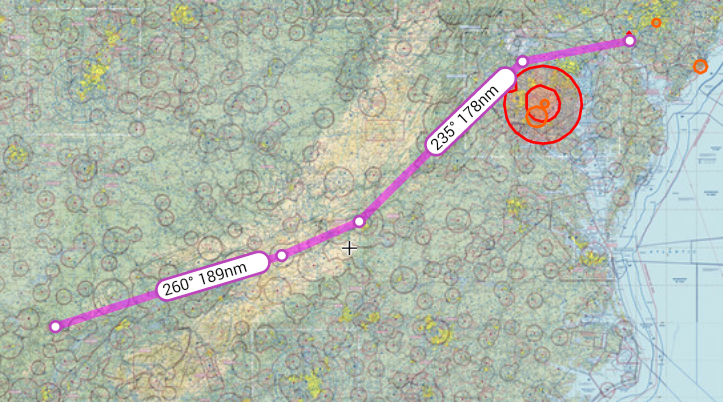
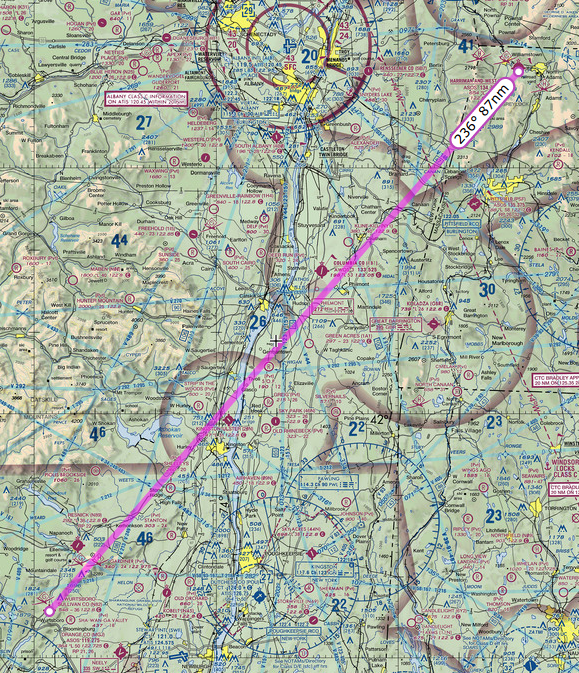
After refuel we took off and had to deal with the Class C airspace right next door. What a pain! instead of letting me turn west then north I had to turn south then east then north and go all the way around. Flying Around Columbus Quite frustrating but I understood afterward that had I gone east then north I would have ended up right in the middle of the approach path for incoming flights. We finally got back on track with flight following and continued to KMIO Miami Municipal Airport located in Miami Oklahoma. Quick note Miami is pronounced “my-am-a” at this particular location as it is a Native American word.

Link To The Route on Skyvector

Had a few moments of excitement on the way in to KMIO. Encountered some moderate rain and approach guided me around the worst of it. Went through about 4 miles of downpour that brought visibility way down. Rain over KMIO

Oh! The best part. The runway at KMIO is closed for repairs. I saw the NOTAM during my morning flight brief on DUATS and called the airport to confirm. The airport manager let me know there was no issue and he instructed me to land on the taxiway. No problem!

NOTAM: MLC 08/194 MIO RWY 17/35 CLSD PARL TWY 4000FT X 50FT AVBL SR-SS VMC 1408121402-1408261400

What a wonderful place. There is one of the longest restored sections of Route 66 running right through the middle of this town. When I called ahead about the runway I also asked about a courtesy car and the manager arranged one for us. Our ride was a big old Ford Crown Victoria that was a retired police car. Miami Route 66It swayed and rattled but ran just great and got us to dinner and our hotel just fine. We had a great dinner at Montana Mike’s and then cruised Historic Route 66 in the courtesy car. While on Route 66 we saw a bunch of restored landmarks including an old gas station, a theater and several shops along the way.

Day 2 July 11

Departed KMIO picked up flight following and flew to our planned refuel stop, Imperial Municipal Airport KIML located in Imperial, Nebraska. We got a great tailwind, which is unusual when traveling west. crop-duster-357 The airport itself was located in the middle of acres of corn fields. The runway seemed to be made of a series of cement tiles connected together, which made my tires click out a tune as we landed. I picked this airport because it was on our route and had some of the least expensive 100 octane low-lead fuel, commonly called 100LL for the plane. Our Piper Cherokee burns about 8 to 10 gallons of fuel in an hour and goes through 40 gallons every four hours of flight. Finding less expensive spots to stop for fuel really saved us some cash.

Link To The Route on Skyvector

The next leg took us from KIML to KRKS Rock Springs – Sweetwater County Airport in Rock Springs, Wyoming. This was the big moment where we flew up to and then across the Colorado rocky mountains. I had thought about this moment quite a bit as I would be flying at 10,000 feet, yet I would only be a few thousand feet above the ground as the peak elevations here would be around 8000 to 9000 feet. Fortunately the northern route afforded us plenty of vertical clearance and an wonderfully scenic flight path.

SkyVector Imperial to Rock Springs

While on flight following we got treated to ATC rerouting several flights due to heavy precipitation over Denver. We stuck to our flight plan of MBW to CKW to OCS which kept us out of the rain. Here is a pic of the storm over Denver. It was enormous.

storm-over-denver-359

The ride into the mountains was turbulent. I was stuck below a near solid cloud layer at about 10,000 feet and bumped along all the way to KRKS. ATC lost us on Radar for a while between Medicine Bow and Cherokee, but picked us back up as we got closer to Rock Springs. Interesting note about the runways at KRKS the 09\27 runway is huge! (10,000 x 150 feet) I hesitated for a moment and had to check the sectional to confirm the runway altitude to set my pattern altitude.

Link To The Route on Skyvector:

The hospitality here was great we were warmly welcomed and chatted it up with the locals about flying conditions on the way in. Got a ride from some nice folks to our hotel. The following day we planned our travel to S75 Payette.

russ-anna-krks-360
Day Three July 12th

Rock Springs to Payette 
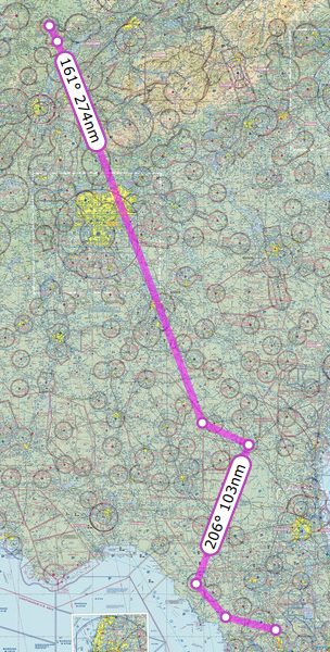
Took off from KRKS Rock Springs early morning and had a very slow climb out. Density Altitude (DA) was already 2000+ at 8:00 am. The field is 6765 feet so DA was 8765+ feet at takeoff. With full fuel and 60 lbs under max weight, we rolled down the runway almost 5000 feet and then climbed ever so slowly at 50-100 feet per minute (fpm). At sea level a normal climb for this plane even fully loaded is around 500-600 fpm. This poor climbing performance made me a bit nervous because the mountain ridge ahead of us was about 8300 feet high. Slowly got to 8500 to clear the mountain ridge, then lowered the nose and flight-climbed to 10,500 feet.

One part of the flight that was particularly scenic was the trip over Bear Lake.and through Logan Pass. We flew west towards and then over Bear Lake to the lakefront town of Garden City.

East Over Bear Lake

Bear lake South

Once over the lake, we then followed the highway past Garden City to the west through the mountain pass into Logan Utah. Really something to see as we approached Logan and the mountain pass made a dramatic drop off a few thousand feet down into the valley where the city of Logan resides.

Logan Pass

Link To The Route On Skyvector:

We continued our flight over the BYI to BOI VORs and then started our decent to S75 – Payette Municipal Airport in Payette, Idaho. Payette is a great little airport with friendly folks. They had the best price on Avgas, also offered 91 octane Mogas, and had a nice courtesy car. I made a bit of a bumpy landing coming in from the south as the rough terrain around the airport produced some turbulence.

I was a little worried about the climb out in the morning. We planned to take off early to the north for that slow climb up to altitude. The following day was the arrival at Johnson Creek.
Day Four July 13th

We set out early from our hotel, drove the courtesy car back to the airport and departed from Payette. Actually had no problem at all taking off as Payette is 2228 ASL and the morning air in the valley was cool with no wind.

Payette to Johnson Creek

For our first landing at Johnson Creek Airport I chose the southern approach. That means I flew southeast from Payette, over Emmett field – S78, turned northeastward to horseshoe bend, then north along the railroad track up to Cascade airport. After that I turned northeastward and followed a road through the notch in the mountain range until I intercepted Johnson Creek. From there I turned north and followed the valley right into Johnson Creek Airport.

The Route on Skyvector:

A brief note on landing at Johnson Creek. The preferred landing runway is 17 as the runway has a 10 degree upwards slope to the south. The canyon walls top out at about 8900 feet ASL but the runway is 4933 ASL. That means you have to fly the pattern at about 5900 feet very close to the runway. When approaching from the south you have to fly the downwind leg very close to the runway and very close to the trees in the canyon. For a first-timer this was intimidating! I found myself watching the trees and the altimeter and struggling to find the altitude that felt safe.

The landing pattern cannot be squared out like we might do back at home. I flew the plane north bound past the field to what is designated as the widest part of the canyon. At this point did a descending 180 degree turn to the left as I added flaps. This did not allow me to descend enough and I was high on final. This is a common rookie mistake. When I was abeam the numbers I should have been a maximum of 800 feet above the runway, however those trees looked really close at that altitude and I opted to stay a bit higher. To make the landing I did a side slip and held it almost all the way to the runway. My first landing was a bit steep and fast, but the runway is 3400 long so I had plenty of space to let the plane roll and burn off speed.

A couple of other points to consider. I was moving way faster in that thin air. Although my airspeed indicator said 70 knots it was in reality closer to 80 knots over the ground. Things happened fast. The direction of the wind through the canyon that day also created an updraft on my downwind leg. I was reducing power and still climbing. I had to push the nose down and reduce power quite a bit to get down to pattern altitude.

Once we landed at Johnson Creek. We camped for the next week. The daytime temperature was almost 100 degrees, at night the temperature would descend to about 45 degrees. This made for some cold nights. The good news is that there is a shed full of extra camping gear left behind and donated by other campers so we were able to find some extra sleeping bags!
The scenery here is breathtaking. The mountains are tall and steep and lush with green. The valleys are spectacular as they are full of life and beauty

Johnson Creek Panorama

Our campsite next to the river with all the comforts of home.

Our campsite at 3U2
Day 8 July 17th

On this day we went to Sulfur Creek ID74, pronounced “crick”, for the famous $20 breakfast. Had sulfur-creek-menua bit of haze during the flight in that we later discovered was smoke. The breakfast menu is very simple. Yes or No. The food was fantastic. The breakfast consisted of eggs, pancakes sausage, home-made apple butt and piping hot coffee. We were able to sit outside and watch other planes come in and land on the runway.

My landing was a bit of an adventure as I think I hit a gopher on landing. Look and see:

Sulphur Creek is a fly-in resort with lodge and cabins. The price to stay there was a bit steep, but you do get all your meals included plus a warm comfy bed in a cabin. After freezing a few nights I was tempted to plunk down the cash for a warm bed!

Sulphur Creek Airstrip
Remember when I mentioned back on day 1 where we flew through some precipitation near KMIO? Well, it seems that precipitation included some very abrasive droplets. The propeller on the plane was stripped nearly clean of all paint on the back side. I made arrangements with a prop shop in Boise Idaho to fix my prop and re-balance it.

On the flight south from Sulfur Creek we flew to KBOI Boise Air Terminal/Gowen Field Airport to get the prop re-balanced. As we traveled south towards the airport the valleys were filled in with smoke and only the very peaks of the mountains were visible.

Smoke in the Moutains

It was a strange experience to see the mountains this way, as only a few days earlier we saw them quite clearly. This also significantly reduced visibility. As I got closer to Boise I estimate I could see about 3 miles in the smoke, sometimes it was even less.

More Smoke in the Mountains

As I got about 20 nm from KBOI, I radioed approach to gain access to the Class C airspace. I was denied and was told to hold outside the airspace. I ended up flying a little racetrack pattern for about fifteen minutes while I waited. I was then granted svfr access and given a specific altitude and vector to fly. I did not see the actual runway until it was very close. Approach guided me to a left base for runway 10R and then turned me over to the tower.

The local prop shop kept my plane overnight and the wife and I spent the night in a local hotel. I slept almost 12 hours as sleep out there in the woods was not as warm and restful as I had hoped.

My Basic Toolkit

I wanted to create a small toolkit for my airplane.  Nothing too fancy here.  Just a simple tool bag that would cover the basic repairs I might encounter.

At the top is the tool bag bought at Big-Lots for $5.99

Top row left to right

  • Digital Volt/Ohm meter
  • Soldering Iron & Solder
  • Lengths of wire
  • Super glue gel (resealable)
  • Twine
  • Electrical tape
  • Ratchet screwdriver & bits in container
  • Small hex head driver
  • Box cutters
  • Medium hex-head driver
  • Medium flat-head driver
  • LCD Flashlight
  • 3/8 socket set with extension
  • Sockets: 1/4-3/4
  • Spark Plug Socket

Second Row Left to Right

  • Twist Pliers
  • .032 Safety Wire (Aviation Grade)
  • Diagonal cutters
  • Mix of common bulbs, screws, fasteners in container
  • 1/2 dozen different size zip ties
  • Hex head wrenches: .050-3/8
  • Wrenches: 9/16 – 3/8
  • Mini Vise-grips
  • Small adjustable wrench

Capturing Organizational Knowledge

Capturing Organizational Knowledge:

Approaches to Knowledge Management and Supporting Technology

By

Russ Wright

Knowledge Management

Although it is said that money makes the world go around, the use of knowledge has displaced money as the primary business driver because, according to Drucker (1988), organizations discovered that organizational knowledge is the most useful tool to use to gain a competitive advantage. Identifying and leveraging knowledge held within the individual and the organization was used to increase their competitiveness (Baird, Henderson, & Watts, 1997). Over the past three decades information and the technology to support it, has grown at an explosive rate and the wealth of information available has rapidly advanced in many fields, including electronics, computers and communications technology (Adomavicius, Bockstedt, Gupta, & Kauffman, 2008). Knowledge management is the inevitable result of rapid progress in Information Technology (IT), globalization and rising awareness of the commercial value of organizational knowledge (Prusak, 2001). The existence of all this information forces organizations to find a way to handle it and transform it into actionable knowledge. Thus the problem exists not only in interpreting, distilling and sharing the information, but also efficiently turning it into knowledge.

The purpose of this document is to explore how knowledge has become the most important resource for an organization and learning is the most important capability for an organization that wants to compete in the marketplace. There is a discussion of the background on creating a competitive advantage and the importance of learning within an organization. This document also compares and contrasts the major approaches to knowledge management within an organization and examines the role that computer technology plays in capturing organizational knowledge. The conclusion finds that the field of knowledge management is still evolving and Web 2.0 technology might change the way knowledge is captured within an organization.

Background

Knowledge for A Competitive Advantage

The realization that knowledge, when organized and viewed through the lens of competitive factors, could help an organization gain a competitive advantage, formalized the beginning of knowledge management. Porter (1980) explained that the existing model of developing a business strategy was no longer working. He created a new model that brought together the ideas of the Harvard Business School and the Boston Consulting Group and created a business strategy commonly called the five forces model as displayed in figure 1 below. This model used five factors of competition as a basis for a business strategy: (1) industry competitors, (2) pressure from substitute products, (3) bargaining power of suppliers, (4) bargaining power of buyers, and (5) potential entrants. The author explained that analysis of these five areas allowed a business within a particular industry to establish themselves and react to these forces of competition and profit from them. Albers and Brewer (2003) explained that examining each of these five forces required specific knowledge within that particular competitive factor. Accordingly, knowledge management began with the need to understand the complexities of each of the five factors. Yet, the knowledge alone was not enough, as organizations had to learn from the analysis of the five factors and adapt to the ever-changing market.

Figure 1

Porter’s Five Forces Model

porter-five-forces

The Learning Organization

Possessing knowledge of competitive factors is not enough of a business strategy to make an organization competitive and profitable. Instead the organization must adapt and take advantage of opportunities to remain competitive because learning is an organization’s most important capability (Earl, 2001; Grant, 1996; Zack, 1999a). Nonaka (1991) explained that learning must be integrated into the culture of the organization and not a separate activity performed by specialists. Senge (1994) described a learning organization as a place where “people continually expand their capacity to create the results they truly desire, where new and expansive patterns of thinking are nurtured, where collective aspiration is set free, and where people are continually learning how to learn together” (p. 1). Thus, a learning organization embraces a culture where the ability to create and share new knowledge will give it a competitive advantage. Still, defining and implementing the required skills for an organization to embrace learning is complicated process.

Creating and sustaining a learning or knowledge-creating culture requires an organization to not only engage in specific activities, but also develop a new mindset. Argyris and Schon (1978) theorized that learning involved not only detecting the error and correcting it, but changing the way the organization behaves as a whole through policy change. Garvin (1993) built upon this work and created a set of activities in which learning organizations must engage to sustain a knowledge-creating culture. The author defined these activities as: (1) systematic problem solving, (2) experimentation with new approaches, (3) learning from their own experience and past history, (4) learning from the experiences and best practices of others, and (5) transferring knowledge quickly and efficiently throughout the organization. The author further explained that applying these practices is not enough, as real change must include an analysis beyond the obvious by delving into the underlying factors. Inasmuch, both learning activities and a culture change are needed to create a learning culture.

All the aforementioned work led to the creation of a field of research commonly called knowledge management. According to Alavi and Leidner (2001), knowledge management is made up of several somewhat overlapping practices that an organization can use to find, create and share knowledge that exists within individuals or processes of an organization. Another view of knowledge management defined it as “an institutional systematic effort to capitalize on the cumulative knowledge that an organization has” (Serban & Jing Luan, 2002, p. 5). Consequently, knowledge management is deeply connected to the people, procedures, and technology within an organization.

Approaches to Knowledge Management

There are different views on the definition of knowledge, which lead to the creation of multiple models of knowledge management (Carlsson, 2003). The first series of approaches to knowledge management, define knowledge as a “Justified True Belief” (Allix, 2003, p. 1). These models place knowledge into different categories (Boisot, 1987; Nonaka & Takeuchi, 1995). The second more scientific type of knowledge management model views knowledge as an asset and connects the value to intellectual capital (Wiig, 1997). The third type of knowledge management views knowledge as subjective and the model focuses on the creation of knowledge within the organization (Demarest, 1997). Which model an organization chooses to use depends upon the organization’s strategic needs (Aliaga, 2000). Thus, there exist many different models of knowledge management for many different needs.

Categorized Knowledge Management

One of the earliest knowledge management models created by Boisot (1987) categorized knowledge into four basic groups as demonstrated in Table 1 below. The first group was codified knowledge which encompassed knowledge that could be packaged for transmission and could have two states, diffused or undiffused. Codified-diffused knowledge was considered public information. Codified-undiffused knowledge was private or proprietary information shared with only a select few. Uncodified knowledge was knowledge that is difficult to package for transmission. Uncodified-undiffused knowledge was personal knowledge. Uncodified-diffused was considered common sense knowledge. The author explained that common sense knowledge develops through the social interactions where individuals share their personal knowledge. The author also pointed out that codified and uncodified are unique categories of knowledge.

Table 1:

Boisot’s Knowledge Category Model

Uncodified Common Sense Personal Knowledge
Codified Public Knowledge Proprietary Knowledge
Diffused Undiffused


The knowledge management model created by Nonaka and Takeuchi (1995) defined two forms of knowledge in their model: tacit and explicit knowledge. They explained that explicit knowledge is knowledge that is shared in some way and gathered into some storage device, such as a book or computer program, which makes it easy to share with others. Tacit knowledge was explained as internal to a person, somewhat subjective, useful only in a specific context, and difficult to share, as it exists only within the mind of the individual. The authors explained that tacit knowledge could be shared through socialization: social interactions, either face to face or in a shared group experience by members of an organization. This knowledge could become explicit knowledge throughexternalization when it is formalized into the information systems of the organization. Explicit knowledge can then be compiled and mixed with other existing knowledge through a process callcombination. Likewise, explicit knowledge could become tacit through a process of internalization, which happens, for example, when members of the organization are trained on how to use a system. When all of these different modes of knowledge transfer work together they create learning in what the author calls “the spiral of knowledge” (p. 165). Through iterations of learning starting at the individual, and spiraling up into the group and eventually the organization, knowledge accumulates and grows which leads to innovation and learning (Nonaka, 1991).

Table 2:

Nonaka’s Knowledge Management Model

Tacit to Tacit → Socialization Tacit to Explicit → Externalization
Explicit to Tacit → Internalization Explicit to Explicit → Combination


When comparing and contrasting these two categorical models, it is easy to see some similarities. The tacit and explicit categories from Nonaka (1991) are somewhat similar to the codified and uncodified knowledge categories defined by Boisot (1987). Another similarity is that tacit and explicit, codified and uncodified knowledge categories are considered unique by both authors. Also, both authors mentioned that their models include a sharing of knowledge, which moves knowledge from the person to the larger group. One place the two models differ greatly is that Nonaka (1991) is much more explicit about the idea of collecting knowledge and creating new knowledge through the knowledge spiral. McAdam and McCreedy (2000) criticized these models as too mechanistic and explained that they lacked a holistic view of knowledge management.

Intellectual Capital as Knowledge Management

The Skandia firm developed a scientific model of knowledge management to help measure their intellectual capital. According to Wiig (1997), this tree-like model treats knowledge as a product that can be considered an asset to the organization. The knowledge or intellectual capital has several categories: (1) human, (2) structural, (3) customer, (4) organizational, (5) process, (6) innovation, (7) intellectual and (8) intangible. The value assigned to each of these categories tells the organization their future capabilities. The author defined each of the categories as:

  • Human capital is the level of competency for the employees.
    Structural capital is the collection of all intellectual activities of the employees.
    Customer capital is the value of the organization’s relationships with their customers.
    Organizational capital is the knowledge embedded in processes.
    Process capital is the value creating processes.
    Innovation capital is the explicit knowledge and inscrutable knowledge assets.
    Intellectual property is documented and captured knowledge.
    Intangible assets are the value of immeasurable, but important items.


When comparing the Skandia model against the Nonaka and Takeuchi (1995) model, it is possible to see the two models share the concept of explicit knowledge, defined as innovation capital within the Skandia model. Although the concept of tacit knowledge is not directly mentioned, Wiig (1997) explained that tacit knowledge that is transferred to explicit to be of lasting value compares to customer capital being transferred to innovation capital in the Skandia model. A study by Grant (1996) criticized the Nonaka and Takeuchi (1995) model because it was based in the context of new product development, whereas the Skandia model would also work for existing products.

Social Construction Model

The last model of knowledge management presented here was created by Demerest (1997) and focused on the creation of knowledge within the context of the organization. The author contends that all organizations have a knowledge economy and in general operate in about the same way. This includes an understanding that commercial knowledge is not truth; instead it is what works for the situation to produce knowledge that leads to an economic gain. One of the primary assumptions of this model is that the knowledge creation process happens through interactions between members of the organization. The author borrowed several concepts and adapted a model created by Clark and Staunton (1989) which includes the four following phases: (1) construction, (2) dissemination, (3) use, and (4) embodiment. The author defined construction as discovering or structuring some knowledge, embodiment as the process of selecting a container for the new knowledge, dissemination as the sharing of this new knowledge and use as creation of commercial value from the new knowledge. The author further explained that process could flow through all four steps in sequence, or happen simultaneously along a few different paths such as construction to use and construction to dissemination.

Figure 2

The Demarest Knowledge Management Model

demarest-km-model

The social construction model seems to be the best of all the other models. When comparing and contrasting this social construction model to the categorical models of Nonaka and Takeuichi (1995) and the Boisot (1987) model, they share (1) the concept of knowledge creation as powered by the flow of information within the organization, (2) the concept that knowledge creation happens between the members of the organization, and (3) include a sharing of knowledge which moves knowledge from the person to the larger group. According to McAdam and McCreedy (2000), this model differed from the categorical and intellectual capital models because the author included the idea that knowledge is inherently connected to the social and learning processes within the organization, and “knowledge construction is not limited to scientific inputs but includes the social construction of knowledge” (p. 6). Therefore this model brings together the best parts of all the other models.

These knowledge management models span a wide range of perspectives on the definition of knowledge management. The categorical models shared the concept of tacit and explicit knowledge. The intellectual capital model considered knowledge as an asset to be managed efficiently to make an organization successful. The social construction model linked knowledge to the social interactions and learning processes within the organization. The progression of models demonstrates that knowledge management continues to evolve. Grover and Davenport (2001) explained that the main purpose of knowledge management models is to help an organization grow their knowledge base and increase their competitive edge in the marketplace. Thus no one model is best to help an organization grow, but instead depends on the perception of the definition of knowledge.

The Role of Computer Technology in Knowledge Management

All the attention on knowledge management has lead to increased use of Information Technology (IT) to capture knowledge. Splender and Scherer (2007) explained that “the majority of KM consultants and business people see IT as KM’s principal armamentarium-it is all about collecting, manipulating, and delivering the increasing amounts of information ITs falling costs have made available” (p. 5). This opinion seems to resonate with Zack (1999b) who proposed a knowledge management strategy for transferring tacit knowledge to a storage format, thereby making it explicit. The author explained that this conversion process is commonly called codified knowledge. He also explained that this model uses IT as a pipeline to connect people to knowledge. Hansen, Nohria and Tierney (1999) proposed an additional strategy of knowledge management architecture that focused on dialog between individuals, thereby sharing tacit to tacit knowledge, which they called personalization. According to the authors this model uses IT to connect people to people and exchange tacit knowledge. Thus, the use of information technology to capture knowledge varies based on the organization’s competitive strategy.

The codified knowledge strategy according to Zack (1999b) is designed to capture knowledge, refine it into something usable, and then place it into a storage device, such as a document repository, where it is reusable by other members of the organization. The ability to store and reuse the knowledge whenever needed creates an economy of reuse, which helps to prevent the constant recreation of knowledge and therefore reduce costs (Cowan & Foray, 1997). According to Hansen et al. (1999), this knowledge strategy, which they call people-to-documents, comes with a significant investment cost for IT because of the need to sort and store large amounts of knowledge, now in data form.

Hansen et al. (1999) defined the personalization knowledge strategy as drawing on the relationships established between individuals in an organization wherein they share tacit knowledge. They further explained that this strategy created an economy of experts within the organization, which they called people-to-people. In contrast they explained that this model required a much smaller investment in IT infrastructure as much less knowledge is stored in any digital format, but instead stays in the minds of the employees.

Managerial Needs

Managers within an organization with a knowledge management strategy need different types of information about the technology used for the knowledge management system. According to research by Jennex and Olfman (2008) managers required multiple factors of measure to gauge the effectiveness and success of a knowledge management system. The managers needed to know about the information quality in the system, how well the users were adapting to using the software, and the overall performance of the knowledge management system. Massey Montoya-Weiss, and O’Driscoll (2002) explained that managers needed information not only about what is in the system, but how well the system was performing so they could assist in removing bottlenecks. Consequently, the information needed by managers, not only gauges the effectiveness of the knowledge management system, but also helps to make the system function smoothly.

Pitfalls

Using information technology to capture the knowledge of an organization might be detrimental if done improperly. In a paper by Johannessen, Olaisen and Olson (2001), the authors expressed much concern over the misuse of information technology to manage tacit knowledge within an organization. They argued that despite the empirical evidence to the contrary organizations continued to invest in IT systems that may lead to a loss of or at least a diminishing of the importance of tacit knowledge. Zack (1999b) explained that competitive performance requires a balance between tacit and explicit knowledge. Nonaka (1994) explained that knowledge within an organization was created by, and flows from the members of an organization engaging each other and sharing tacit and explicit knowledge. Scheepers, Venkitachalam and Giibs (2004) extended the research of Hansen et al. (1999) and concluded that an 80/20 mix of codification and personalization strategy, based on the competitive strategy of the organization was most successful. For these reasons, a balance between tacit and explicit knowledge must be maintained in the organization’s culture and IT infrastructure.

Web 2.0

The new technologies created in the Web 2.0 culture offer some new IT solutions to knowledge management. Web 2.0 technology functions more like the way individuals interact (O’Reilly, 2006). As previously stated, the codified knowledge strategy requires a significant IT investment not only in equipment but also specialists to gather and organize the knowledge (Hansen et al., 1999). According to Liebowitz (1999) one of the problems with traditional knowledge management technology is that it put the user in the role of passive receiver. Tredinnik (2006) in reference to Web 2.0 technology in knowledge management explained: “The technologies involved place a greater emphasis on the contributions of users in creating and organizing information than traditional information organization and retrieval approaches.”(p. 231). Chu, Miller and Roberts (2009) echoed this same concept when they explained that Web 2.0 technology puts the emphasis on the users generating new information or editing other participant’s work. According to Levy (2009) one of the advantages of Web 2.0 technology is that as individuals shared the knowledge they potentially assisted in the codification process. When they shared their tacit knowledge by posting it in an interactive Web 2.0 tool, such as a wiki, the knowledge began to move to explicit as others read, enhanced and categorized this knowledge, which moved it up from personal to organizational knowledge. Accordingly, web 2.0 technologies potentially offers many benefits, among them are more user participation creating more knowledge sharing, which helps keep the knowledge from becoming stale and lower costs as participants do more of the work.

Information technology for knowledge management and specifically capturing organization knowledge depends on the organization’s competitive strategy. The two strategies outlined here, codified and personalization knowledge strategy use information technology in different ways because the former builds a repository requiring significant IT investment and the latter creates a loose network of experts which requires a smaller IT investment. The experts warn that technology itself is not the answer and a real strategy with clear plans needs to be in place or the technology investment will not help the knowledge management process. There are some new Web 2.0 technologies on the horizon that could positively impact user participation in knowledge management technology and save money when codifying knowledge.

Knowledge Management Is Still Evolving

The approaches to knowledge management outlined here show a progression of thought. The models show a progression from a specific portion of knowledge sharing and an absolute definition of knowledge as truth (Boisot, 1987; Nonaka, 1991), to a wider and more generic perspective of sharing knowledge and a more subjective definition of commercial knowledge as truth (Demarest, 1997). Also, the information technology used to support the knowledge management strategy continues to evolve. Both the codified knowledge strategy of Zack (1999b) and the personalization knowledge strategy of Hansen et al. (1999) require technology to capture and share the knowledge. New Web 2.0 technology possesses a potential to change how much of an investment in technology the organization must make, as this technology is likely to increase the level of participation of the users making them more active in the knowledge management process. Therefore the only certainty of knowledge management is the continued growth and change of the models, strategies and technology.


References

Adomavicius, G., Bockstedt, J. C., Gupta, A., & Kauffman, R. J. (2008). Making sense of technology trends in the information technology landscape: A design science approach. MIS Quarterly,32(4), 779-809.


Alavi, M., & Leidner, D. E. (2001). Review: Knowledge management and knowledge management systems: Conceptual foundations and research issues. MIS Quarterly, 25(1), 107-136.


Albers, J., & Brewer, S. (2003). Knowledge management and the innovation process: The eco-innovation model. Journal of Knowledge Management Practice, 4(1).


Aliaga, O. A. (2000). Knowledge management and strategic planning. Advances in Developing Human Resources, 2(1), 91-104. doi:10.1177/152342230000200108


Allix, N. (2003). Epistemology and knowledge management concepts and practices. Journal of Knowledge Management Practice, 4(1), 136-152.


Argyris, C., & Schön, D. (1978). Organizational learning: A theory of action perspective. Reading, MA: Addison Wesley.


Baird, L., Henderson, J., & Watts, S. (1997). Learning from action: An analysis of the center for army lessons learned. Human Resource Management Journal, 36(4), 385-396.


Boisot, M. (1987). Information and organizations: The manager as anthropologist. London, UK: Fontana/Collins.


Carlsson, S. (2003). Knowledge managing and knowledge management systems in inter-organizational networks. Knowledge and Process Management, 10(3), 194-206. doi:10.1002/kpm.179


Chui, M., Miller, A., & Roberts, R. P. (2009). Six ways to make Web 2.0 work. The McKinsey Quarterly, 1-7.


Clark, P., & Staunton, N. (1989). Innovation in technology and organization. London, UK: Routleedge.


Cowan, R., & Foray, D. (1997). The economics of codification and the diffusion of knowledge.Industrial and Corporate Change, 6(3).


Demarest, M. (1997). Understanding knowledge management. Long Range Planning, 30(3), 374-384. doi:10.1016/S0024-6301(97)90250-8


Drucker, P. F. (1988). The coming of the new organization. Harvard Business Review, 66(1), 45-53.


Earl, M. (2001). Knowledge management strategies: Toward a taxonomy. Journal of Management Information Systems, 18(1), 215-233.


Garvin, D. A. (1993). Building a learning organization. Harvard Business Review, 71(4), 78-91.


Grant, R. (1996). Prospering in dynamically-competitive environments: Organizational capability as knowledge integration. Organization Science, 7(4), 375-387.


Grover, V., & Davenport, T. H. (2001). General perspectives on knowledge management: Fostering a research agenda. Journal of Management Information Systems, 18(1), 5-21.


Hansen, M. T., Nohria, N., & Tierney, T. (1999). What’s your strategy for managing knowledge?Harvard Business Review, 77(2), 106-116.


Jennex, M. E., & Olfman, L. (2008). A model of knowledge management success. In Current Issues in Knowledge Management (pp. 34-52). Hershey, PA: Information Science Reference.


Johannessen, J. (2001). Mismanagement of tacit knowledge: The importance of tacit knowledge, the danger of information technology, and what to do about it. International Journal of Information Management, 21(1), 3-20. doi:10.1016/S0268-4012(00)00047-5


Levy, M. (2009). WEB 2.0 implications on knowledge management. Journal of Knowledge Management,13(1), 120-134. doi:10.1108/13673270910931215


Liebowitz, J. (1999). Key ingredients to the success of an organization’s knowledge management strategy. Knowledge and Process Management, 6(1), 37-40.


Massey, A. P., Montoya-Weiss, M. M., & O’Driscoll, T. M. (2002). Knowledge management in pursuit of performance: Insights from nortel networks. MIS Quarterly, 26(3), 269-289.


McAdam, R., & McCreedy, S. (2000). A critique of knowledge management: Using a local constructionist model. New Technology, Work & Employment, 15(2), 155.


Nonaka, I. (1991). The knowledge-creating company. Harvard Business Review, 85(7/8), 162-171.


Nonaka, I. (1994). A dynamic theory of organizational knowledge creation. Organization Science, 5(1), 14-37.


Nonaka, I., & Takeuchi, K. (1995). The knowledge creating company: How Japanese companies create the dynamics of innovation. Oxford, UK: Oxford University Press.


O’Reilly, T. (2006). Web 2.0 compact definition: Trying again. O’Reilly radar. Retrieved January 24, 2011, from http://radar.oreilly.com/2006/12/web-20-compact-definition-tryi.html


Porter, M. (1980). Competitive strategy: Techniques for analyzing industries and competitors. New York: Free Press.


Prusak, L. (2001). Where did knowledge management come from? IBM Systems Journal, 40(4), 1002-1007.


Scheepers, R., Venkitachalam, K., & Gibbs, M. (2004). Knowledge strategy in organizations: refining the model of Hansen, Nohria and Tierney. The Journal of Strategic Information Systems, 13(3), 201-222. doi:10.1016/j.jsis.2004.08.003


Senge, P. (1994). The fifth discipline: the art and practice of the learning organization (1st ed.). New York: Doubleday/Currency.


Serban, A. M., & Jing Luan. (2002). Overview of knowledge management. New Directions for Institutional Research, 2002(113), 5.


Spender, J., & Scherer, A. (2007). The philosophical foundations of knowledge management: Editors’ introduction. Organization, 14(1), 5-28.


Tredinnick, L. (2006). Web 2.0 and business: A pointer to the intranets of the future? Business Information Review, 23, 228-234.


Wiig, K. (1997). Integrating intellectual capital and knowledge management. Long Range Planning,30(3), 399-405. doi:10.1016/S0024-6301(97)90256-9


Zack, M. H. (1999a). Developing a knowledge strategy. California Management Review, 41(3), 125-145.


Zack, M. H. (1999b). Managing codified knowledge. Sloan Management Review, 40(4), 45-58.